average_ew
- average_ew(fs, area, increment)
Computes the zonal average for each field in
fsfor a set of latitude belts.- Parameters
fs (
Fieldset) – input fieldsetarea (list) – area as [N,W,S,E] to perform the averaging
increment (number) – increment in degrees defining the size of the latitude belts
- Return type
1d-ndarray or 2d-ndarray
If
fsonly contains one field a 1d-ndarray is returned otherwise the result is a 2d-ndarray.The averaging is performed for each field individually within the latitude belts defined by
areaandincrement. Each grid point value is weighted by the cosine of its latitude. Missing values are ignored. If a latitude belt contains no grid point values Nan is returned for that belt.- Example
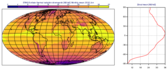
ave = mv.average_ew(fs, [60,-180,-60,180], 2.5)
Here we compute the averages over full latitude circles starting from 60N, stepping by 2.5 degrees until 60S. If
fscontains only one field the output will be a 1d-ndarray of 49 E-W average values, from North to South. Iffscontains n fields then the output will be an array of n 1d-arrays each containing 49 values. Each value in the result represents the average at latitude Lat based on those grid points whose latitude coordinate is between Lat-1.25 and Lat+1.25 (1.25 is 2.5/2), i.e. within a latitude belt with width of 2.5 degrees, centered around Lat.
Note
See also
average_ns().