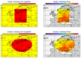
rmask
- rmask(fs, circle, missing=False)
- rmask(fs, lat, lon, radius, missing=False)
For each field in
fscreates a field containing grid point values of 0 or 1 according to whether their distance to a given geographical location is larger or smaller than a given radius. 0 is assigned to points outside the radius and 1 to points inside the radius. An additional named argument,missingset toTruewill change the behaviour so that points outside the area will become missing values and points inside the area retain their original value.- Parameters
fs (
Fieldset) – input fieldsetcircle (list[number]) – circle as a list of [lat, lon, radius]
lat (number) – latitude coordinate of the centre of the circle
lon (number) – longitude coordinate of the centre of the circle
radius (number) – radius of the circle in m
missing (bool) – set to
Trueto change the behaviour as described above. New in Metview version 5.13.0.
- Return type
Note
See also
mask(),poly_mask(),bitmap()andnobitmap().