Version 5.8 Updates
Version 5.8.3
Externally released on 2020-04-30
Became metview/new at ECMWF on 2020-04-30 (Linux desktops, ecgate, lxc, lxop)
At ECMWF:
Geopoints:
when reading a line of a geopoints file that has an error in it, Metview will now fail and return an empty geopoints rather than risk returning wrong values
Macro/Python:
fixed issue where file handles were not being closed after simple operations on netCDF data, such as ‘a = nc + 1’
fixed issue where valid_date() function did not correctly interpret steps whose units are minutes
fixed issue where first_derivative_y() function crashed when processing GRIB encoded from South to North (also affected the vorticity() function)
fixed issue where saturation_vapour_pressure() used mixed phase; now it uses water phase by default and is controllable by passing a second parameter to the function:
saturation_vapour_pressure(t, phase)
where phase can be one of “water”, “ice” or “mixed”
Build:
now uses the standard CMake way of putting the project version number directly into the CMakeLists.txt file
Version 5.8.2
Externally released on 2020-04-01
Became metview/new at ECMWF on 2020-04-01 (Linux desktops, ecgate, lxc, lxop)
At ECMWF:
Plotting:
when built with Magics 4.3.1, a crash in the interactive plotting window has been fixed (triggered when visualising a GRIB file with multiple fields)
Macro/Python:
fixed issue when creating an empty NCOLS-formatted geopoints with the create_geo() function
fixed issue when using a numpy array of indexes into a Fieldset
Version 5.8.1
Externally released on 2020-03-10
Became metview/new at ECMWF on 2020-03-10 (Linux desktops, ecgate, lxc, lxop)
At ECMWF:
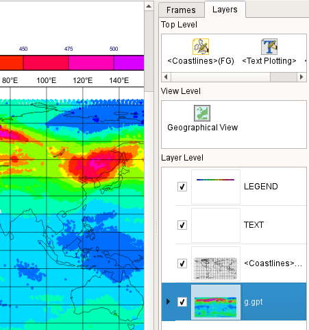
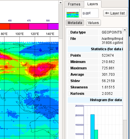
Plotting:
simplified the switching between layer and data tabs in the interactive plot window
the Data tab is no longer required in the side panel
to access the metadata and statistics for a given layer, just double-click on its thumbnail in the sidebar
to get back to the list of layers, click the Layer List button
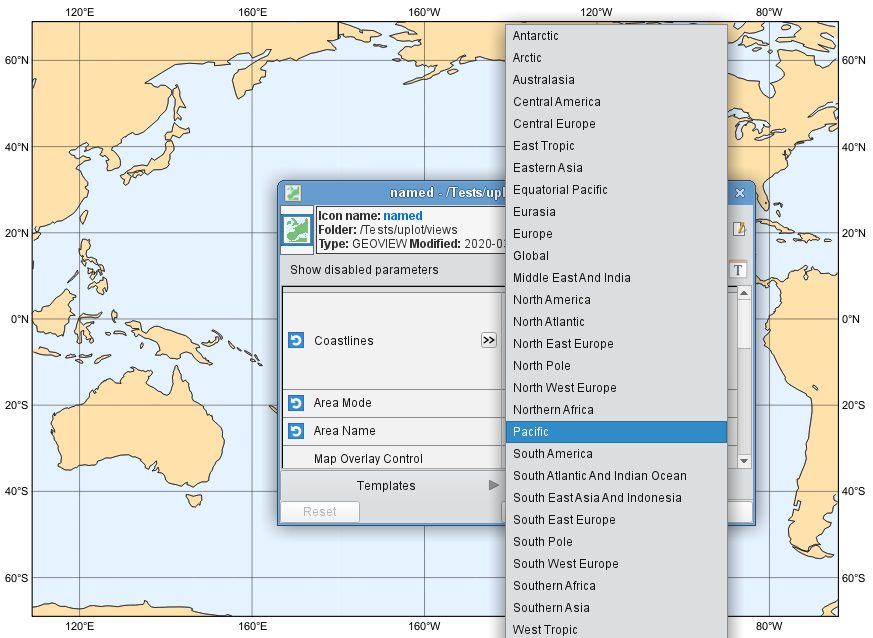
the Geographical View icon has new parameters to enable the selection of predefined areas and projections by setting Area Mode to Name and then selecting from the drop-down list of areas to set the Area Name parameter:
new parameter in the Legend icon to control the size of the main legend box
legend_automatic_box_margin is a percentage of the width/length of the main plot area (the subpage) that will not be taken up by the main legend box. The default is to leave a 5% gap on either end - to make the legend the same size as the plot area, set this parameter to 0 (zero).
with Magics 4.3.0, the Cursor Data now works with NetCDF files where netcdf_position_type is ‘matrix’
the ECCHARTS icon has changed the behaviour of the Step parameter so that it behaves the same way as in the MARS Retrieval icon
the ECCHARTS icon has a new parameter, Title, which can be used to select a formatting style for the title; options are Default and Style 1
GRIB:
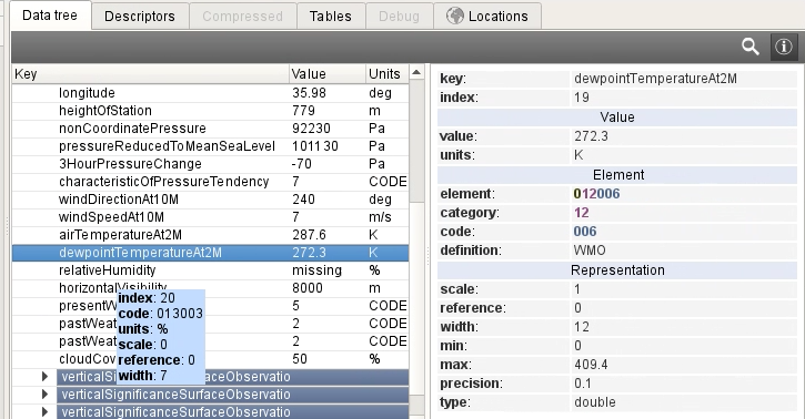
added a filter to the standard namespace dump for easier location of keys

BUFR:
the BUFR Examiner now shows the possible minimum and maximum values for each descriptor based on the available bits per value and its scaling factor
the BUFR Examiner now shows the total number of subsets across all messages

improved performance when the BUFR Examiner is initially scanning the messages in the given BUFR file
improved performance when unpacking messages
Desktop:
new startup option ‘-fs’ followed by a font size to specify the default font size for everything in the user interface; now you can start Metview like this for large fonts:
metview -fs 16
fixed issue where dropping a MARS Retrieval icon into a Python code editor generated the parameter name
clsinstead of the correctclass_fixed issue where the data examiners and Code Editor did not work on macOS Catalina
Macro/Python:
new function to compute relative humidity from temperature and dewpoint:
relative_humidity_from_dewpoint(t, td)
Works for numbers, vectors and fieldsets. Input values should be in K.
functions saturation_vapour_pressure(), mixing_ratio() and vapour_pressure() now work with vectors and fields
improved general performance of geopoints operations by keeping data in memory more often and only writing to disk when really necessary
the function metadata(geopoints) will now return an empty definition/dictionary if there is no metadata; previously nil/None was returned
in Python, allow indexed assignment using any type (e.g. strings) as an index; the particular case in mind was this:
gp = metview.create_geo(type='ncols',vals_0=numpy.array([10.,20.,30.]))
gp['vals_0'] = numpy.array([-10.,-20.,-30])
new function purge_mem() to release unused memory; this can be called at any time
the nearest_gridpoint() function that takes a geopoints variable as the list of target points now has a new parameter, ‘store_locs’, which, if present, will ensure that the resulting geopoints will be of type NCOLS and will contain the additional columns nearest_latitude and nearest_longitude, which contain the co-ordinates of the nearest gridpoint in the field
nearest_gridpoint(my_fieldset, my_geopoints, “store_locs”)
improved the way that functions are exposed to the Python layer
changed slightly the behaviour of the nearest_gridpoint() function when providing a geopoints for the target points:
The resulting geopoints will contain all the coordinate columns from the input geopoints (with date, time and level taken from the GRIB), and one value column only, taken from the GRIB. The value columns from the input geopoints are discarded. The metadata from the input geopoints is also discarded, as it is probably not valid for the GRIB data.
fixed an issue in the nearest_gridpoint() function whereby it did not preserve the stnid column from an input geopoints
fixed an issue in the surrounding_points_indexes() function when the input is a global regular lat/lon grid that does not start at the poles and the target point is outside the first/last latitude
fixed an issue in the surrounding_points_indexes() function for reduced lat/lon grids when the target point is outside the area (defined by zeros in the ‘pl’ array)
fixed issue where some temporary files were not cleaned up on exit of a Python script
fixed issue where a NetCDF file was not closed after being read
fixed issue where the wmsclient command did not work under Python